Friday Harbor, Vereinigte Staaten
San Juan Islands
2 places
Place
Mt. Constitution Observation Tower
Place
Lime Kiln Point Lighthouse
While unknown to many, Washington's beauty is beyond compare.
Trip story
While unknown to many, Washington's beauty is beyond compare. The state is home to an extraordinarily diverse landscape, with rainforests, alpine mountain ranges and urban Seattle in the west, and arid stretches of desert in the east. With so many activities, everybody is sure to have a great time!
Western Washington
San Juan Islands:
In the strait of San Juan de Fuca, in between mainland Washington and Vancouver Island in Canada, lies the San Juan archipelago. The islands are known for their tranquility and untouched wilderness, with numerous state parks throughout the 172 islands. The archipelago can be reached via Washington State Ferry or as a stop on a whale-watching tour, departing from Port Townsend. Visit San Juan Island, the archipelago's most populous island, and drive or ride a (rental) bike to Lime Kiln Point State Park. Lime Kiln Point is considered one of the best places on the planet to see whales, such as Orcas, Humpbacks, or porpoises. Watch as the pods make their way through the Strait from May through September. Hop on over to Orcas Island, the largest island of the San Juans, and hike (or drive) up Mount Constitution in Moran State Park. On its peak, at 734 m (2,407 ft) stands a lookout tower, from where visitors can enjoy magnificent 360° ocean views and on a clear day, can even see as far as glacier-covered Mount Baker in the Northern Cascades! Continue to explore Moran State Park by following the various trails available, ranging from beginner-friendly walks to more challenging hikes.
Olympic Peninsula:
In the northwestern corner of Washington State, surrounded by the waters of the Pacific Ocean, the Strait of San Juan de Fuca, and Puget Sound, lies a mostly untouched paradise: the Olympic Peninsula. Lined with beaches and with lush, mossy forests and the stunning mountain peaks of the Olympic National Park at its core, the peninsula promises an adventurous journey. Find out more: Olympic Peninsula Roundtrip
Mt. Rainier National Park:
Looming in the background of Seattle's skyline is Mount Rainier. The active volcano stands at 4,932 m (14,411 ft) and is a must-see destination for travelers all year round. The best times, however, to visit the mountain are in early summer when the wildflowers are starting to bloom all around the trails in the park, or during winter for an action-packed trip in the snow. To reach the summit of Mount Rainier you will need to be an experienced climber, as the mountain is surrounded by a total of 25 glaciers in all directions. However, there are multiple great viewing spots all around the park! Take the panoramic Mt. Rainier Gondola to the peak of Crystal Mountain, from which you can see Mt Rainier (almost) up close. Or drive up the winding roads of Mt Rainier to reach Henry M Jackson Visitor's Center. The southeastern route up Steven's Canyon passes countless waterfalls, while the southwestern route follows the scenic Nisqually River through Paradise Valley. On the way to Steven's Canyon lies an easy 2,5 km (1,5 mile) trail, The Grove of the Patriarchs, leading visitors across a suspension bridge over the Ohanapecosh River, through an old-growth forest onto a small island in the woods. Here, they can marvel at the ancient trees of the enchanting grove, some more than 1000 years old!
Seattle:
Previously known as the door to the Klondike Gold Rush, Seattle itself has managed to morph into the shiny main attraction of the pacific northwest. It lies directly on the waters of Puget Sound and is surrounded by the Cascade Mountain Range to the east and the rainforests on the Olympic Peninsula to the west. The city is home to an impressive skyline, featuring its most notable architectural landmark, the Space Needle, in front of a spectacular view of the volcano Mount Rainier, the highest peak in the Cascades. If you are a fan of city trips, this dynamic city is one you should not miss out on! Find out more: Seattle
North Cascades National Park:
Located on the border to British Columbia lie the Northern Cascades. This part of the Cascade Range is sometimes adequately dubbed "the North American Alps" due to the enormity and diversity of the landscape: Snow-capped mountains interspersed with bright grasslands, deep forests, striking blue lakes, and gushing waterfalls constitute the region. Much of the park is designated wilderness, making it mainly accessible for hikers. Thus, most visitors stick to Highway 20, dividing the park in the Skagit River Valley, and to trails nearby. Luckily, many beautiful locations in the park can be reached this way! Washington Pass Overlook marks the highest point of Highway 20 at 1,6 km (5,500 ft) above sea level. The observation deck is a mere 400 m (1,312 ft) walk along a paved, wheelchair-accessible path from the parking lot. Jaw-dropping vistas await at the overlook: to their right, visitors can admire the 2,4 km (8,000 ft) tall peaks of the Liberty Bell Mountain Group, and Kangaroo Ridge to their left. Continuing just a short stint westwards along Highway 20, you'll find Blue Lake and Rainy Lake. The easy trail to Blue Lake is 3,2 km (2 miles) long and climbs about 320 m (1050 ft) in elevation. The turquoise lake is surrounded by trees and the granite peaks of the Liberty Bell mountains. Don't miss out on the gorgeous views of Blue Lake! Rainy Lake can be accessed via a wheelchair-friendly, 1.6 km (1 mile) long pathway. Alpine-like steep gravel and woodlands encircle this crystal clear lake, making it less startling than Blue Lake but just as compelling. Waterfalls at the far side of the lake, flowing gracefully from the mountains into the lake, perfectly complete the view. The last stop on the Northern Cascade Highway is Lake Diablo. The reservoir was created through the installation of Diablo Dam, providing electricity to the greater Seattle Area. Directly off the main road is a vista point, which offers a stunning view of the mountains that tower over the brightly colored lake. "Glacial flour", fine rock from glacier erosions, gives the lake its recognizably milky-turquoise color. For those wanting to explore the area further, Diablo Lake Trail may be an option. The trail is 12,1 km (7,5 miles) roundtrip and not suited for complete beginners due to its length and the elevation gain of 469 m (1,538 ft). For their efforts, hikers receive panoramic views of the mountain peaks, as well as cascading waterfalls!
Eastern Washington
East of the Cascade Range, where rainy clouds coming from the pacific have emptied, begins Eastern Washington. Instead of snowy mountains and emerald forests, the landscape is defined by hilly desert and deep running canyons, with valleys of fertile farmland and vineyards, sprinkled in between.
Yakima River:
Right through the heart of Washington flows the Yakima River, carving its way through the towering basalt cliffs of the Columbia Plateau. Known as a great spot for fishing and rafting, the river canyon is a favorite among families and thrill-seekers alike. Follow its 43 km (27 miles) path (by car or by raft!) between Ellensburg and Yakima fully take in the stunning nature of the canyon. Selah Creek and Rattlesnake Dance Ridge are just two of the many hiking trails in this area but offer the best short-hike views of the Yakima canyon. Selah Creek Trail takes hikers on a 4 km (2.5 miles) roundtrip through the Selah Cliffs Natural Area Preserve and offers a closer look at the giant basalt cliffs, that shape the area. Rattlesnake Dance Ridge Trail is a short, but very steep 3 km (2 miles) hike up a ridge of the river canyon and rewards hikers with an amazing outlook of the hilly landscape surrounding the river. As the trails take you through dry shrublands, beware of rattlesnakes lingering in the bushes. Stay on marked trails and listen carefully, then there should be no incidences. The Yakima Valley, further down the river, breaks up the shrubby desert of the canyon with the lush vineyards of central Washington's wine country. Enjoy the sun in the aptly named town of Sunnyside while visiting the many fantastic wineries.
Channeled Scablands:
Eastern Washington is home to a unique topography, found nowhere else on earth: large areas of granite bedrock, with odd rock formations sticking out of the ground and deep canyons, called coulees, that cut through the bedrock. The channeled scablands were formed during the last ice age when a dam, formed by glacial ice, broke and water flooded the lands in a series of events named the "Missoula Floods". The enormous flood, releasing as much water as in Lake Erie and Lake Ontario combined, carried away the soil and brought bedrock to light. Visit Dry Falls, a cliff which, 10,000 years ago, was the largest waterfall in the world, and explore Moses Coulee and Grand Coulee, the largest, to take in the extraordinary scenery.
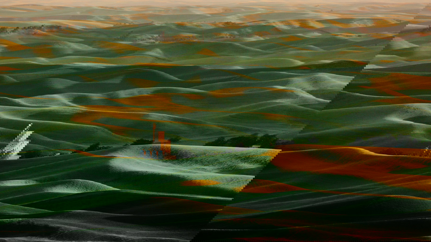
Palouse Hills:
By the border to Idaho, the dry, arid scablands turn into another stunning vista. Rolling hills of farmland fill the view as far as the eye can see, their colors changing with the light and the seasons. The Palouse is a favorite among locals, photographers, and visitors, for its picturesque serenity. Hike or drive up the spiraling road to the tall peak of Steptoe Butte, for beautiful panoramic views of the surrounding Palouse, or spend a sunset picnic in Kamiak Butte County Park.
Spokane:
While it is the second-largest city in the state, Spokane's strengths lie again in its nature experiences, rather than in urban life. Located in the middle of the city is Manito Park. The botanical garden showcases multiple flower beds and thematic gardens, such as a Japanese Garden or Duncan Garden, which strongly resembles European gardens from the baroque period. Manito is ideal for a peaceful stroll through the park, offering many park benches and picnic spots to sit and linger. Visit Spokane Falls in the business district of the city to see the rushing waterfalls created by a dam on the Spokane River and spend your lunch in Riverfront Park not far from the falls. To get a full panoramic view of the park and waterfall ride the SkyRide, a gondola lifting its passengers above the falls and taking them for a 15-minute scenic ride along the waterfront. Just outside the city lies Riverside State Park. Hikers and birdwatchers will enjoy the many trails around the park, such as the Bowl and Pitcher Loop Trail which takes hikers on a 3.3 km (2.1 miles) journey along the river. The trail leads over a suspension bridge, and later forks to overlook the rapids or the basalt rock formations lining the river, and finally connects again to form a loop. Thrill-seekers may go on a whitewater kayak or rafting tour, get their adrenaline kick from waterskiing or climb the large rocks found all around the park.
Media
Itinerary
Each stop anchors the route, with saved places shown underneath whenever they exist.
Friday Harbor, Vereinigte Staaten
Place
Mt. Constitution Observation Tower
Place
Lime Kiln Point Lighthouse
Port Angeles, USA
Place
Point Wilson Lighthouse
Place
Mt Townsend Trailhead
Place
Lake Crescent
Place
Sol Duc Hot Springs Resort
Place
Cape Flattery
Place
Forks, WA
Place
Ruby Beach
Place
Hoh Rainforest
Place
World's Largest Sitka Spruce
Place
Olympia
Place
Billy Frank Jr. Nisqually National Wildlife Refuge
Carbonado, Vereinigte Staaten
Place
CM Mt. Rainier Gondola
Place
Paradise - Henry M. Jackson Visitor Center
Place
Nisiqually River Crossing
Place
Grove of the Patriarchs
Vereinigte Staaten
Place
Space Needle
Place
Pike Place Market
Place
Gas Works Park
Place
Seattle Ferry Terminal
Place
Bainbridge Island
Place
Bill Speidel's Underground Tour
Place
Alki Point
Rockport, Vereinigte Staaten
Place
Washington Pass Overlook
Place
Rainy Lake Trailhead
Place
Diablo Lake Vista Point
Place
Blue Lake Trailhead
Place
Blue Lake Trailhead
United States
Place
Dry Falls Heritage Area
Place
Moses Coulee
Place
Grand Coulee
Vereinigte Staaten
Place
Selah Cliffs
Place
Rattlesnake Dance Ridge Trailhead
Place
Sunnyside, WA
Palouse, USA
Place
Steptoe Butte State Park
Place
Kamiak Butte County Park
Vereinigte Staaten
Place
Manito Park
Place
Riverside State Park
Place
Spokane Falls
Place
Riverfront Park